Difference between revisions of "File:Teignmouth Den satellite image.png"
Jump to navigation
Jump to search
(Satellite image of the Den in Teignmouth, from Google Maps UK. Adaptive filter, 320b block split threshold, 500 tries with random tables.) |
m (Fix link to moved page) |
||
| (2 intermediate revisions by the same user not shown) | |||
| Line 1: | Line 1: | ||
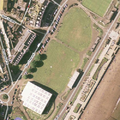
Satellite image of [[ | Satellite image of [[Teignmouth Den | the Den]] in [[Teignmouth]], from Google Maps UK. | ||
Adaptive filter, 320b block split threshold, 500 tries with random tables. | Adaptive filter, 320b block split threshold, 500 tries with random tables. | ||
[[Category:A Seaside Rendezvous]] | |||
Latest revision as of 14:15, 8 September 2009
Satellite image of the Den in Teignmouth, from Google Maps UK.
Adaptive filter, 320b block split threshold, 500 tries with random tables.
File history
Click on a date/time to view the file as it appeared at that time.
| Date/Time | Thumbnail | Dimensions | User | Comment | |
|---|---|---|---|---|---|
| current | 15:59, 18 August 2009 |  | 500 × 500 (429 KB) | Tene (talk | contribs) | Satellite image of the Den in Teignmouth, from Google Maps UK. Adaptive filter, 320b block split threshold, 500 tries with random tables. |
You cannot overwrite this file.
File usage
The following page uses this file: